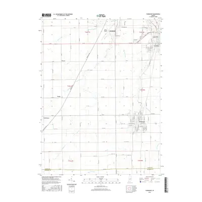
2016 Map of Fairmount
USGS Topo · Published 2016About this map
Fairmount and the southern outskirts of Marion anchor this 2016 landscape, which documents the rural and municipal layout of southern Grant County. The area is defined by a dense network of county roads and drainage systems, including Tappin Ditch, Dry Fork Ditch, and Winslow Ditch, which support the agricultural productivity of the region. The northeastern corner shows the concentrated development of Gas City and Jonesboro, separated from the more rural west by the Mississinewa River. Smaller established locales like Hackleman, Radley, and Weaver appear as clusters along the major thoroughfares. For genealogists and local historians, the map provides precise locations for Park Cem and the Marion Municipal Airport, while also detailing the transition from city grids to the expansive sections of the Public Land Survey System as one moves toward the Grant and Madison county line.
Find a feature on this map
77 named features on this map. Tap any name to fly to it.
Don’t see what you’re looking for? This feature index may not catch every label — zoom into the map to look around manually.
Map Details
Editions of this 2016 Fairmount Map
This is the sole edition of this map. No revisions or reprints were ever made.
Other maps of this area

1953 · Muncie
USGS Topo · 1:250,000

1956 · Muncie
USGS Topo · 1:250,000

1960 · Elwood
USGS Topo · 1:24,000

1960 · Point Isabel
USGS Topo · 1:24,000

1960 · Alexandria
USGS Topo · 1:24,000

1960 · Fairmount
USGS Topo · 1:24,000

1960 · Gas City
USGS Topo · 1:24,000

1960 · Gaston
USGS Topo · 1:24,000

1961 · Marion
USGS Topo · 1:24,000
1962 · Sweetser
USGS Topo · 1:24,000