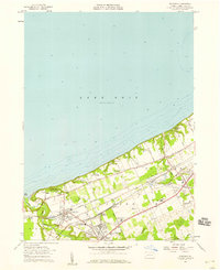
1957 Map of Fairview
USGS Topo · Published 1958About this map
Lake Erie defines the northern edge of this Pennsylvania landscape, where the shoreline is punctuated by summer retreats like Camp Sherwin and Camp Caledon. The interior reflects a mid-century period of established borough life and institutional growth, anchored by the settlements of Fairview and Girard. Extensive rail infrastructure, including the New York Central Railroad and the New York Chicago and St Louis Railroad, creates a dense corridor of tracks through Lake City, meeting at key interchanges like Wallace Junction and Girard Junction. Local community life is visible in the distribution of schools and churches, such as the Rice Avenue Union High Sch and the Divine Word Seminary. Beyond the town centers, the land is divided by a network of named roads like Middle Road and Lake Road, interspersed with local industry like gravel pits and the County Airport.
Find a feature on this map
43 named features on this map. Tap any name to fly to it.
Don’t see what you’re looking for? This feature index may not catch every label — zoom into the map to look around manually.
Map Details
Editions of this 1957 Fairview Map
4 editions found
Other maps of this area

1899 · Erie
USGS Topo · 1:62,500

1900 · Girard
USGS Topo · 1:62,500

1900 · Erie
USGS Topo · 1:62,500

1900 · Fairview
USGS Topo · 1:62,500

1923 · Cambridge Springs
USGS Topo · 1:62,500

1925 · Cambridge Springs
USGS Topo · 1:62,500

1943 · Cambridge Springs
USGS Topo · 1:62,500

1950 · Cleveland
USGS Topo · 1:250,000

1950 · Erie
USGS Topo · 1:250,000

1956 · Cleveland
USGS Topo · 1:250,000