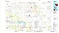
1986 Map of Fairview
USGS Topo · Published 1986About this map
Canton Lake serves as a central landmark in this 1980s-era map of Major County and its surroundings, where the North Canadian River flows through the Canton State Wildlife Management Area. The landscape is defined by the stark geography of the Glass Mountains and Lone Mtn, contrasted with the productive valleys of the Cimarron River and Cottonwood Creek. The distribution of small towns like Cheyenne Valley, Cedar Springs, and Bouse Junction reflects the agrarian settlement patterns of the Oklahoma plains.
Find a feature on this map
84 named features on this map. Tap any name to fly to it.
Don’t see what you’re looking for? This feature index may not catch every label — zoom into the map to look around manually.
Map Details
Editions of this 1986 Fairview Map
2 editions found
Other maps of this area

1892 · Kingfisher
USGS Topo · 1:125,000

1893 · Hennessey
USGS Topo · 1:62,500

1893 · Loyal
USGS Topo · 1:62,500

1893 · Ames
USGS Topo · 1:62,500

1895 · Kingfisher
USGS Topo · 1:125,000

1954 · Oklahoma City
USGS Topo · 1:250,000

1955 · Enid West
USGS Topo · 1:24,000

1955 · Clinton
USGS Topo · 1:250,000

1955 · Enid
USGS Topo · 1:250,000

1955 · Woodward
USGS Topo · 1:250,000