1918 Map of Fairview
USGS Topo · Published 1922About this map
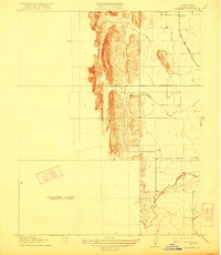
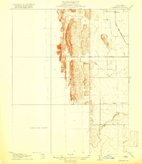
The small settlement of Fairview occupies the northeast corner of this early twentieth-century survey, situated at the terminus of a local rail line. The Colusa and Lake railroad provides a critical transport link through this portion of the Sacramento Valley, connecting the rural landscape to broader commerce. The topography is defined by the transition from the level floor of Glenn Valley into the prominent ridges and canyons to the west. This map is particularly interesting for its documentation of a Preliminary Edition Unsurveyed Area, leaving a significant portion of the western territory as a blank canvas during this phase of the State of California Department of Engineering collaboration. Hydrological features like the Glenn Valley Slough and the winding course of Freshwater Creek illustrate the natural drainage patterns that shaped early land use and ranching in the region.
Find a feature on this map
6 named features on this map. Tap any name to fly to it.
Don’t see what you’re looking for? This feature index may not catch every label — zoom into the map to look around manually.
Map Details
Editions of this 1918 Fairview Map
2 editions found
Other maps of this area

1904 · Kaweah
USGS Topo · 1:125,000

1905 · Olancha
USGS Topo · 1:125,000

1905 · Fairview
USGS Topo · 1:24,000

1906 · Kernville
USGS Topo · 1:125,000

1907 · Olancha
USGS Topo · 1:125,000

1908 · Kernville
USGS Topo · 1:125,000

1909 · Kaweah
USGS Topo · 1:125,000
1918 · Fairview
USGS Topo · 1:31,680

1936 · Tobias Peak
USGS Topo · 1:125,000

1937 · Kaweah
USGS Topo · 1:125,000