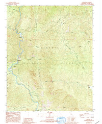
1987 Map of Fairview
USGS Topo · Published 1994About this map
The Kern River carves a deep path through the southern reaches of the Sequoia National Forest, defining the geography of this Tulare County region during the late 1980s. The settlement of Fairview sits along the riverbanks, serving as a focal point for backcountry access near the Greenhorn Mountains. This survey documents a landscape structured by recreation and resource extraction, where Limestone Campground and Fairview Campground provide access to the water, while the Fairview Mine and various prospects suggest the area's mineral interests. Significant natural landmarks including Salmon Creek Falls and the subterranean Packsaddle Cave are precisely located. The mapping of Rincon Canyon and several meadows, such as Poison Meadow and Horse Meadow, illustrates the complex drainage systems feeding the Kern from the surrounding high ground.
Find a feature on this map
35 named features on this map. Tap any name to fly to it.
Don’t see what you’re looking for? This feature index may not catch every label — zoom into the map to look around manually.
Map Details
Editions of this 1987 Fairview Map
4 editions found
Other maps of this area

1904 · Kaweah
USGS Topo · 1:125,000

1905 · Olancha
USGS Topo · 1:125,000

1905 · Fairview
USGS Topo · 1:24,000

1906 · Kernville
USGS Topo · 1:125,000

1907 · Olancha
USGS Topo · 1:125,000

1908 · Kernville
USGS Topo · 1:125,000

1909 · Kaweah
USGS Topo · 1:125,000

1918 · Fairview
USGS Topo · 1:31,680

1936 · Tobias Peak
USGS Topo · 1:125,000

1937 · Kaweah
USGS Topo · 1:125,000