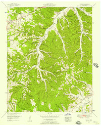
1951 Map of Fairview
USGS Topo · Published 1970About this map
Fairview and the winding course of the Harpeth River define this rural landscape on the border of Davidson and Williamson Counties. The area is characterized by a dense network of named hollows, such as Tally Hollow, Sugar Camp Hollow, and Tobacco Patch Hol, reflecting a century of localized agricultural use and family settlement patterns. Along the South Fork Harpeth River, the community of Fernvale sits near several family cemeteries, including the King Cem and Lampley Cem, providing valuable data for genealogical research.
Find a feature on this map
68 named features on this map. Tap any name to fly to it.
Don’t see what you’re looking for? This feature index may not catch every label — zoom into the map to look around manually.
Map Details
Editions of this 1951 Fairview Map
4 editions found

Other maps of this area

1901 · Colombia
USGS Topo · 1:125,000

1903 · Nashville
USGS Topo · 1:125,000

1909 · Franklin
USGS Topo · 1:62,500

1930 · White Bluff
USGS Topo · 1:62,500

1932 · Nashville
USGS Topo · 1:62,500

1933 · White Bluff
USGS Topo · 1:62,500

1936 · Primm
USGS Topo · 1:24,000

1936 · Spring Hill
USGS Topo · 1:24,000

1936 · Theta
USGS Topo · 1:24,000

1936 · Craigfield
USGS Topo · 1:24,000