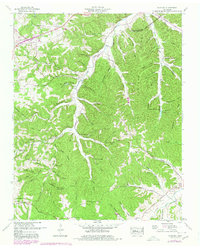
1951 Map of Fairview
USGS Topo · Published 1980About this map
Fairview and the surrounding Williamson County uplands are defined by the winding course of the South Fork Harpeth River and its myriad tributaries. This 1951 survey, updated with 1977 aerial data, shows a landscape of narrow hollows and high ridges such as Peach Orchard Ridge and Backbone Ridge. The agrarian and social character of the mid-century era is preserved through numerous family-named landmarks and rural institutions, including the Boy Scout Camp and the Tennessee Industrial School Camp. Small communities like Fernvale and Leipers Fork are connected by historic routes, most notably the Natchez Trace which cuts through the southeastern corner. Deeply localized history is evident in the density of small burial grounds like Russell Cem and King Cem, alongside rural centers of worship such as Pewitt Chapel and Pond Ch. The topography reveals the complex drainage patterns of Lick Creek and Arkansas Creek before they join the main river valley.
Find a feature on this map
73 named features on this map. Tap any name to fly to it.
Don’t see what you’re looking for? This feature index may not catch every label — zoom into the map to look around manually.
Map Details
Editions of this 1951 Fairview Map
4 editions found

Other maps of this area

1901 · Colombia
USGS Topo · 1:125,000

1903 · Nashville
USGS Topo · 1:125,000

1909 · Franklin
USGS Topo · 1:62,500

1930 · White Bluff
USGS Topo · 1:62,500

1932 · Nashville
USGS Topo · 1:62,500

1933 · White Bluff
USGS Topo · 1:62,500

1936 · Primm
USGS Topo · 1:24,000

1936 · Spring Hill
USGS Topo · 1:24,000

1936 · Theta
USGS Topo · 1:24,000

1936 · Craigfield
USGS Topo · 1:24,000