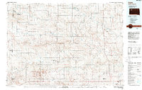
1984 Map of Faith
USGS Topo · Published 1988About this map
The Moreau River and its numerous tributaries, including Rabbit Creek and Thunder Butte Creek, dominate this western South Dakota landscape during the mid-1980s. This survey captures a region defined by its water management and aviation network, featuring various private facilities like the Meyer Landing Strip and Lensegrav Airstrip alongside the larger Municipal Landing Field near Faith. The topography is marked by distinct rises such as Rabbit Butte and Stony Butte, while the water resources are anchored by Maurine Lake and the Sorum Dam State Game Production Area. The settlement pattern is sparse, focusing on rural centers like Maurine, Zeona, and Sorum. This map illustrates the intersection of Perkins, Meade, and Butte counties, showing the transition from the Plateau region through various local draws and creek basins that supported the area's ranching and agricultural life.
Find a feature on this map
86 named features on this map. Tap any name to fly to it.
Don’t see what you’re looking for? This feature index may not catch every label — zoom into the map to look around manually.
Map Details
Editions of this 1984 Faith Map
3 editions found
Other maps of this area

1913 · Newell
USGS Topo · 1:125,000

1935 · Reva
USGS Topo · 1:125,000

1935 · Hoover
USGS Topo · 1:125,000

1951 · Cedar Canyon
USGS Topo · 1:24,000

1951 · Maurine
USGS Topo · 1:24,000

1951 · Redelm NW
USGS Topo · 1:24,000

1951 · Faith NE
USGS Topo · 1:24,000

1951 · Imogene
USGS Topo · 1:24,000

1951 · Deep Creek NW
USGS Topo · 1:24,000

1951 · Bixby
USGS Topo · 1:24,000