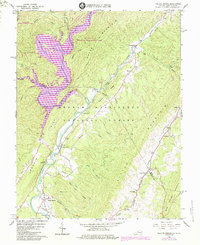
1966 Map of Falling Spring
USGS Topo · Published 1984About this map
Lake Moomaw dominates the western reaches of this survey, its waters sprawling through the Gathright Wildlife Management Area and into the valley of the Jackson River. The landscape is defined by the heavy ridges of Coles Mountain and Warm Springs Mountain, which channel the region's rural settlements into narrow corridors. Along the eastern slopes, small communities like Carloover and Valley View sit near the headwaters of Falling Spring Run.
Find a feature on this map
38 named features on this map. Tap any name to fly to it.
Don’t see what you’re looking for? This feature index may not catch every label — zoom into the map to look around manually.
Map Details
Editions of this 1966 Falling Spring Map
3 editions found
Other maps of this area

1887 · Lewisburg
USGS Topo · 1:125,000

1891 · Lewisburg
USGS Topo · 1:125,000

1891 · Huntersville
USGS Topo · 1:125,000

1894 · Huntersville
USGS Topo · 1:125,000

1894 · Natural Bridge
USGS Topo · 1:125,000

1901 · Monterey
USGS Topo · 1:125,000

1921 · Callaghan
USGS Topo · 1:48,000

1923 · Marlinton
USGS Topo · 1:48,000

1923 · Warm Springs
USGS Topo · 1:48,000

1923 · Callaghan
USGS Topo · 1:62,500