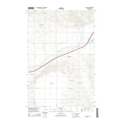
2014 Map of Fallon SW
USGS Topo · Published 2014About this map
Bluffport and Fallon sit along the southern banks of the Yellowstone River in this eastern Montana landscape. The river dominates the northern half of the region, featuring the White Island Rapids and receiving numerous tributaries such as Skunk Arroyo, Coal Creek, and Deer Creek. The terrain transitions from the river valley to the elevated Broadview Bench in the southwest, a flat-topped landform dissected by drainage systems like Mamies Coulee.
Find a feature on this map
28 named features on this map. Tap any name to fly to it.
Don’t see what you’re looking for? This feature index may not catch every label — zoom into the map to look around manually.
Map Details
Editions of this 2014 Fallon SW Map
This is the sole edition of this map. No revisions or reprints were ever made.
Other maps of this area

1953 · Miles City
USGS Topo · 1:250,000

1957 · Miles City
USGS Topo · 1:250,000

1958 · Miles City
USGS Topo · 1:250,000

1966 · Fallon
USGS Topo · 1:24,000
1967 · Fallon NE
USGS Topo · 1:24,000

1969 · Zero NE
USGS Topo · 1:24,000

1969 · Flat Top Butte
USGS Topo · 1:24,000

1969 · Flat Top Butte NE
USGS Topo · 1:24,000

1972 · Hendrickson Coulee
USGS Topo · 1:24,000

1972 · Diamond G Creek
USGS Topo · 1:24,000