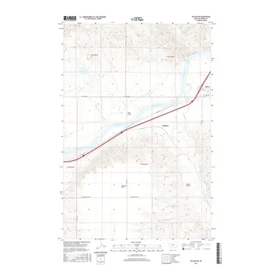
2017 Map of Fallon SW
USGS Topo · Published 2017About this map
The Yellowstone River cuts a wide path through this Prairie County landscape, flowing past the White Island Rapids and the small settlement of Fallon. The map documents a significant transport corridor where E Old Hwy 10 and modern infrastructure parallel the river's southern bank, connecting the community of Bluffport to the surrounding ranching and agricultural lands. To the south, the terrain rises toward Broadview Bench, a prominent flat-topped feature defined by drainage networks including Mamies Coulee and Brights Valley Cr. This 2017 survey provides a detailed look at the rural eastern Montana landscape, showing the distribution of water resources such as the Coal Cr Reservoir and the winding course of O'Fallon Cr. Genealogists and local historians will find value in the placement of the Fallon Cem and the specific naming of regional landmarks like Skunk Arroyo and Newman Hollow Cr.
Find a feature on this map
29 named features on this map. Tap any name to fly to it.
Don’t see what you’re looking for? This feature index may not catch every label — zoom into the map to look around manually.
Map Details
Editions of this 2017 Fallon SW Map
This is the sole edition of this map. No revisions or reprints were ever made.
Other maps of this area

1953 · Miles City
USGS Topo · 1:250,000

1957 · Miles City
USGS Topo · 1:250,000

1958 · Miles City
USGS Topo · 1:250,000

1966 · Fallon
USGS Topo · 1:24,000
1967 · Fallon NE
USGS Topo · 1:24,000

1969 · Zero NE
USGS Topo · 1:24,000

1969 · Flat Top Butte
USGS Topo · 1:24,000

1969 · Flat Top Butte NE
USGS Topo · 1:24,000

1972 · Hendrickson Coulee
USGS Topo · 1:24,000

1972 · Diamond G Creek
USGS Topo · 1:24,000