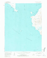
1963 Map of False Pass D-2
USGS Topo · Published 1972About this map
Deer Island dominates the eastern reaches of this maritime survey, rising from the waters where the Pacific Ocean meets the entrance to Cold Bay. This mid-century coastal study records the intricate shoreline of the Aleutian landscape before modern developments, highlighting critical navigational landmarks like Telegraph Hill and the protrusion of Thin Point. The map provides detailed bathymetric data, showing the depths of Thinpoint Cove and the sheltered Fox Island Anchorage.
Find a feature on this map
24 named features on this map. Tap any name to fly to it.
Don’t see what you’re looking for? This feature index may not catch every label — zoom into the map to look around manually.
Map Details
Editions of this 1963 False Pass D-2 Map
2 editions found
Other maps of this area

1943 · Fort Randall
USGS Topo · 1:250,000

1949 · False Pass
USGS Topo · 1:250,000

1949 · Fort Randall
USGS Topo · 1:250,000

1950 · False Pass
USGS Topo · 1:250,000

1950 · Fort Randall
USGS Topo · 1:250,000
1963 · False Pass D-3
USGS Topo · 1:63,360
1963 · False Pass C-2
USGS Topo · 1:63,360

1963 · False Pass D-1
USGS Topo · 1:63,360

1963 · False Pass D-2
USGS Topo · 1:63,360
1963 · False Pass C-1
USGS Topo · 1:63,360