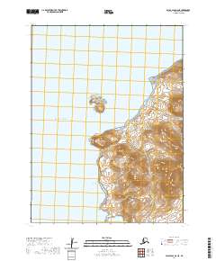
2020 Map of False Pass D-2 NE
USGS Topo · Published 2020About this map
Deer Island dominates the southeastern quadrant of this coastal survey, where steep topography meets the northern reaches of the Pacific Ocean. The coastline is defined by prominent landforms such as West Cape and Bent Cape, framing the sheltered waters of Bent Cove. This sub-arctic maritime landscape in the Aleutians East region reveals a remote environment where small islands like Fox Island and protected areas such as Fox Island Anchorage serve as critical points of reference for navigation. The proximity of Cold Bay and the narrow corridor of Deer Passage highlights a topography shaped by coastal erosion and glaciation, where the few named drainage features like Southern Cr indicate the runoff patterns of this maritime environment.
Find a feature on this map
14 named features on this map. Tap any name to fly to it.
Don’t see what you’re looking for? This feature index may not catch every label — zoom into the map to look around manually.
Map Details
Editions of this 2020 False Pass D-2 NE Map
This is the sole edition of this map. No revisions or reprints were ever made.
Other maps of this area

1943 · Fort Randall
USGS Topo · 1:250,000

1949 · False Pass
USGS Topo · 1:250,000

1949 · Fort Randall
USGS Topo · 1:250,000

1950 · False Pass
USGS Topo · 1:250,000

1950 · Fort Randall
USGS Topo · 1:250,000

1963 · False Pass D-1
USGS Topo · 1:63,360

1963 · False Pass D-2
USGS Topo · 1:63,360
1983 · Cold Bay A-1
USGS Topo · 1:63,360
1995 · Cold Bay A-2
USGS Topo · 1:63,360
2020 · False Pass D-1 NW
USGS Topo · 1:25,000