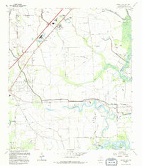
1994 Map of Fannett East
USGS Topo · Published 1994About this map
Hillebrandt Bayou and its winding tributaries define the low-lying landscape of Jefferson County in this mid-1990s revision. The area shows a transition from rural agricultural land to industrial and recreational utility, marked by the extensive network of pipelines and drainage features like Pevitot Gully and Din Gully. Small communities such as Fannett, Cheek, and Galloway anchor the northwestern corner, while family history is preserved at Broussard Cem and Landrum Cem.
Find a feature on this map
35 named features on this map. Tap any name to fly to it.
Don’t see what you’re looking for? This feature index may not catch every label — zoom into the map to look around manually.
Map Details
Editions of this 1994 Fannett East Map
This is the sole edition of this map. No revisions or reprints were ever made.
Other maps of this area

1926 · Vidor
USGS Topo · 1:24,000

1932 · Beaumont
USGS Topo · 1:62,500

1943 · Fannett East
USGS Topo · 1:24,000

1943 · Beaumont East
USGS Topo · 1:24,000

1945 · Fannett East
USGS Topo · 1:31,680

1950 · Houston
USGS Topo · 1:250,000

1954 · Beaumont
USGS Topo · 1:250,000

1955 · Sour Lake
USGS Topo · 1:62,500

1956 · Houston
USGS Topo · 1:250,000

1957 · Beaumont
USGS Topo · 1:250,000