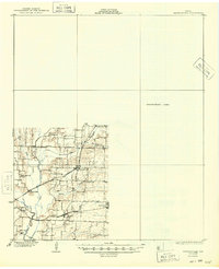
1930 Map of Farmersville
USGS Topo · Published 1949About this map
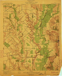
Copeville and Nevada anchor the southeastern corner of Collin County in this survey conducted during the late 1910s and early 1920s. The landscape is defined by the complex drainage of the East Fork Trinity River and its tributaries, including Pilot Grove Creek and Rocky Creek. A significant rural educational network is visible through numerous localized schoolhouses such as Mesquite Sch, Cairo Sch, and Neathery Sch, reflecting a time of dispersed farming communities before consolidation. Rail transport was central to local commerce, with the Gulf Colorado and Santa Fe and the St Louis Southwestern lines, including the Cotton Belt route, cutting through the countryside. To the east, a large portion of the map remains an Unsurveyed Area, contrasting with the detailed topography of settlements like Stringtown and Lavon.
Find a feature on this map
24 named features on this map. Tap any name to fly to it.
Don’t see what you’re looking for? This feature index may not catch every label — zoom into the map to look around manually.
Map Details
Editions of this 1930 Farmersville Map
2 editions found
Other maps of this area

1891 · Dallas
USGS Topo · 1:125,000

1893 · Dallas
USGS Topo · 1:125,000
1912 · Rockwall
USGS Topo · 1:31,680

1919 · Royse City
USGS Topo · 1:62,500

1924 · Farmersville 3-c
USGS Topo · 1:48,000

1924 · Mc Kinney 4-d
USGS Topo · 1:48,000

1929 · McKinney
USGS Topo · 1:62,500

1930 · Farmersville
USGS Topo · 1:62,500

1954 · Dallas
USGS Topo · 1:250,000

1954 · Sherman
USGS Topo · 1:250,000