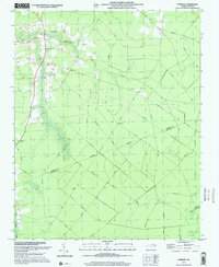
1997 Map of Farmlife
USGS Topo · Published 2001About this map
Farmlife and the surrounding coastal plain of eastern North Carolina define this landscape, where agricultural tradition and swampy lowlands intersect. The area is marked by a complex network of man-made drainage systems, such as Hardison Canal and Smithwick Canal, which were essential for managing the waters of Deep Run Swamp and Big Swamp for local farming. This 1997 revision, based on earlier imagery, preserves the layout of rural community life centered around the Manning Farmlife Sch, Maple Grove Ch, and the Manning Cem. The terrain is crisscrossed by numerous named forest and farm roads, including Daniels Road No 1 and Diamond City Road, leading to the small settlement of Diamond. The southern portion of the map is defined by the heavy timber and wetlands of Waters Swamp and Fork Swamp along the Martin Co Beaufort Co line.
Find a feature on this map
37 named features on this map. Tap any name to fly to it.
Don’t see what you’re looking for? This feature index may not catch every label — zoom into the map to look around manually.
Map Details
Editions of this 1997 Farmlife Map
This is the sole edition of this map. No revisions or reprints were ever made.
Other maps of this area

1901 · Williamston
USGS Topo · 1:62,500

1902 · Williamston
USGS Topo · 1:62,500

1903 · Chocowinity
USGS Topo · 1:62,500

1905 · Chocowinity
USGS Topo · 1:62,500

1943 · Plymouth
USGS Topo · 1:125,000

1950 · Pinetown
USGS Topo · 1:24,000

1951 · Bunyan
USGS Topo · 1:24,000

1951 · Washington
USGS Topo · 1:24,000

1953 · Rocky Mount
USGS Topo · 1:250,000

1954 · Rocky Mount
USGS Topo · 1:250,000