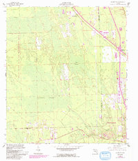
1956 Map of Favoretta
USGS Topo · Published 1993About this map
Favoretta and the surrounding landscape of the Florida coast reveal a transition from wetland wilderness to mid-century roadside development. The map is defined by the vast Hull Cypress Swamp and Lake Swamp, providing a look at the region’s hydrology before extensive modern drainage. While much of the area is dedicated to the Relay State Wildlife Management Area, human influence is clustered along the established transit corridors.
Find a feature on this map
15 named features on this map. Tap any name to fly to it.
Don’t see what you’re looking for? This feature index may not catch every label — zoom into the map to look around manually.
Map Details
Editions of this 1956 Favoretta Map
5 editions found
Other maps of this area

1937 · Ormond
USGS Topo · 1:48,000

1944 · Ormond
USGS Topo · 1:62,500

1952 · Daytona Beach
USGS Topo · 1:24,000

1954 · Daytona Beach
USGS Topo · 1:250,000

1956 · Favoretta
USGS Topo · 1:24,000

1956 · Flagler Beach East
USGS Topo · 1:24,000

1956 · Flagler Beach West
USGS Topo · 1:24,000

1956 · Ormond Beach
USGS Topo · 1:24,000

1958 · Daytona Beach
USGS Topo · 1:250,000

1962 · Daytona Beach NW
USGS Topo · 1:24,000