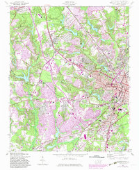
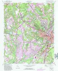
1957 Map of Fayetteville
USGS Topo · Published 1983About this map
Fayetteville serves as the central hub for this mid-century portrait of Cumberland County, showing the city's residential expansion alongside major institutional landmarks. The map details the academic grounds of Fayetteville State University and the Newbold Training Sch, while documenting the growth of suburban neighborhoods like Haymount, Lakedale, and Bonnie Doone. The influence of the adjacent Fort Bragg Military Reservation is evident along the northwestern boundary, where the landscape transitions from military woods to urban grids. Transportation networks are meticulously recorded, including the Cape Fear and Yadkin Valley Railway and significant local arteries like Morganton Road and Raeford Road. Smaller communities such as Cumberland and Victory are shown in the southern reaches near the Fayetteville Municipal Airport Grannis Field, surrounded by numerous local congregations including Grace Ch and Magnolia Ch.
Find a feature on this map
66 named features on this map. Tap any name to fly to it.
Don’t see what you’re looking for? This feature index may not catch every label — zoom into the map to look around manually.
Map Details
Editions of this 1957 Fayetteville Map
5 editions found
Other maps of this area

1948 · Fayetteville
USGS Topo · 1:62,500

1948 · Clifdale
USGS Topo · 1:62,500

1948 · Slocomb
USGS Topo · 1:24,000

1948 · Clifdale
USGS Topo · 1:24,000

1949 · Vander
USGS Topo · 1:24,000

1950 · Clifdale
USGS Topo · 1:24,000

1950 · Fayetteville
USGS Topo · 1:24,000

1950 · Manchester
USGS Topo · 1:24,000

1950 · Slocomb
USGS Topo · 1:24,000

1951 · Clifdale
USGS Topo · 1:62,500