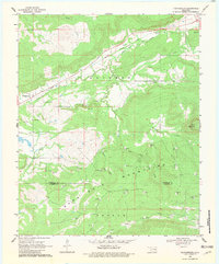
1969 Map of Featherston
USGS Topo · Published 1982About this map
Quinton Gas Field dominates the landscape of eastern Oklahoma in this late-1960s survey, illustrating a region defined by energy extraction and the prominent ridge of the Sans Bois Mountains. The settlement of Featherston serves as a local anchor along Featherston Creek, while the broader terrain is marked by numerous Gas Wells and a network of pipelines that traverse the hills. Cultural landmarks such as Bascom Ch and the Featherston Cem offer points of interest for those researching local family history near the Pittsburg Co Latimer Co line.
Find a feature on this map
21 named features on this map. Tap any name to fly to it.
Don’t see what you’re looking for? This feature index may not catch every label — zoom into the map to look around manually.
Map Details
Editions of this 1969 Featherston Map
2 editions found

Other maps of this area

1898 · McAlester
USGS Topo · 1:125,000

1900 · Sansbois
USGS Topo · 1:125,000

1900 · Canadian
USGS Topo · 1:125,000

1901 · Tuskahoma
USGS Topo · 1:125,000

1908 · Tuskahoma
USGS Topo · 1:125,000

1909 · Mc Alester
USGS Topo · 1:125,000

1909 · Tuskahoma
USGS Topo · 1:125,000

1909 · Sans Bois
USGS Topo · 1:125,000

1911 · Sansbois
USGS Topo · 1:125,000

1946 · Fort Smith
USGS Topo · 1:250,000