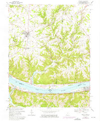
1968 Map of Felicity
USGS Topo · Published 1976About this map
Felicity and Augusta anchor this topographic view of the river borderland, where the Ohio River carves its path between Ohio and Kentucky. In the late 1960s, the landscape remained characterized by winding country roads like Bolender Road and Felicity Cedron Road, connecting small farming communities and family burial grounds such as Smyrna Cem and Hopewell Cem. The Chesapeake and Ohio railroad follows the Kentucky shoreline through Wellsburg, illustrating the critical role of the river valley in regional transportation. Further downstream, the settlement of Utopia and the historic location of Boudes Ferry highlight old river-crossings and early landing sites. The dissected terrain is defined by numerous drainage systems including Bullskin Creek and Bear Creek, which have shaped the local ridges and valleys.
Find a feature on this map
45 named features on this map. Tap any name to fly to it.
Don’t see what you’re looking for? This feature index may not catch every label — zoom into the map to look around manually.
Map Details
Editions of this 1968 Felicity Map
2 editions found
Other maps of this area

1915 · Maysville
USGS Topo · 1:62,500

1919 · Maysville
USGS Topo · 1:62,500

1928 · Higginsport
USGS Topo · 1:48,000

1931 · Felicity
USGS Topo · 1:62,500

1931 · Higginsport
USGS Topo · 1:62,500

1952 · Germantown
USGS Topo · 1:24,000

1952 · Higginsport
USGS Topo · 1:24,000

1952 · Berlin
USGS Topo · 1:24,000

1952 · Brooksville
USGS Topo · 1:24,000

1953 · Laurel
USGS Topo · 1:24,000