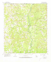
1958 Map of Felixville
USGS Topo · Published 1973About this map
The Amite River winds through the heart of the Feliciana parishes, creating a natural boundary between East Feliciana and St. Helena. This mid-century survey reveals a landscape deeply connected to its rural community hubs, such as the Felixville post office and the small cluster at Woodland. The terrain is defined by a dense network of tributaries including Sandy Creek, Darling Creek, and McQuinney Bayou, which have historically shaped the settlement patterns of the region.
Find a feature on this map
88 named features on this map. Tap any name to fly to it.
Don’t see what you’re looking for? This feature index may not catch every label — zoom into the map to look around manually.
Map Details
Editions of this 1958 Felixville Map
4 editions found
Other maps of this area

1906 · Bayou Sara
USGS Topo · 1:125,000

1939 · Zachary
USGS Topo · 1:62,500

1941 · Woodland
USGS Topo · 1:31,680

1941 · Norwood
USGS Topo · 1:31,680

1941 · Gilead
USGS Topo · 1:31,680

1941 · Chipola
USGS Topo · 1:31,680

1942 · Montpelier
USGS Topo · 1:31,680

1942 · Liverpool
USGS Topo · 1:31,680

1942 · Pine Grove
USGS Topo · 1:31,680

1942 · Pride
USGS Topo · 1:31,680