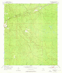
1954 Map of Fenholloway
USGS Topo · Published 1976About this map
San Pedro Bay and the interconnected wetlands of the Florida panhandle dominate this mid-century landscape, where water dictates the patterns of human activity. The Fenholloway River and its accompanying Spoil Bank cut through the northern reaches, flanked by the Southern railroad line which serves the small settlement of Fenholloway. This terrain is characterized by numerous sogs—distinctive local depressions such as Fire Pan Sog, Blue Sog, and Big Sog—that create a complex drainage network flowing toward Middle Warrior Creek.
Find a feature on this map
14 named features on this map. Tap any name to fly to it.
Don’t see what you’re looking for? This feature index may not catch every label — zoom into the map to look around manually.
Map Details
Editions of this 1954 Fenholloway Map
3 editions found
Other maps of this area

1954 · Fenholloway
USGS Topo · 1:24,000

1954 · Day SE
USGS Topo · 1:24,000

1954 · Day
USGS Topo · 1:24,000

1954 · Cooks Hammock
USGS Topo · 1:24,000

1954 · Warrior Swamp
USGS Topo · 1:24,000

1954 · Salem
USGS Topo · 1:24,000

1954 · Boyd
USGS Topo · 1:24,000

1954 · Day NW
USGS Topo · 1:24,000

1954 · Gainesville
USGS Topo · 1:250,000

1954 · Valdosta
USGS Topo · 1:250,000