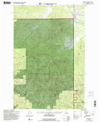
1995 Map of Fernwood
USGS Topo · Published 1997About this map
Fernwood sits along the St Maries River at the northeastern edge of this mid-1990s survey, marking a pocket of settlement surrounded by the vast timberlands of the St Joe National Forest. The landscape is dominated by high peaks and ridges, including Green Mountain, Carpenter Mountain, and Hoodoo Mountain. Historically significant resource extraction is evident through several clusters of dredge tailings and mines located along Emerald Creek and its tributaries, while the Palouse St Maries Rd provides the primary passage through the high country. Water drainage patterns are clearly defined by numerous named gulches and creeks such as Garnet Gulch and Tyson Creek, which carve through the terrain between the Benewah and Latah County line.
Find a feature on this map
31 named features on this map. Tap any name to fly to it.
Don’t see what you’re looking for? This feature index may not catch every label — zoom into the map to look around manually.
Map Details
Editions of this 1995 Fernwood Map
2 editions found
Other maps of this area

1955 · Pullman
USGS Topo · 1:250,000

1955 · Spokane
USGS Topo · 1:250,000

1957 · Emida
USGS Topo · 1:62,500

1958 · Spokane
USGS Topo · 1:250,000

1958 · Pullman
USGS Topo · 1:250,000

1961 · Deary
USGS Topo · 1:62,500

1961 · Fernwood
USGS Topo · 1:62,500

1961 · Bovill
USGS Topo · 1:62,500

1981 · St Maries
USGS Topo · 1:100,000

1981 · Potlatch
USGS Topo · 1:100,000