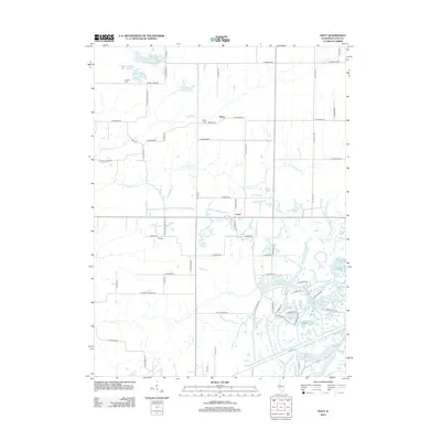
2012 Map of Fiatt
USGS Topo · Published 2012About this map
Fiatt and the surrounding Fulton County landscape appear here as a patchwork of agricultural acreage and significant water features. The southeastern portion of the map is defined by the intricate shoreline of Lake Wee-Ma-Tuk, a major water body surrounded by smaller named basins including Marie Lake, Mason Lake, and Lake Louise. This concentration of water, including Fisher Lake and Genes Pond, suggests a legacy of specialized land use or land reclamation that contrasts with the rectilinear road grid found further north.
Find a feature on this map
68 named features on this map. Tap any name to fly to it.
Don’t see what you’re looking for? This feature index may not catch every label — zoom into the map to look around manually.
Map Details
Editions of this 2012 Fiatt Map
This is the sole edition of this map. No revisions or reprints were ever made.
Other maps of this area

1912 · Canton
USGS Topo · 1:62,500

1915 · Avon
USGS Topo · 1:62,500

1918 · Vermont
USGS Topo · 1:62,500

1921 · Vermont
USGS Topo · 1:62,500

1925 · Havana
USGS Topo · 1:62,500

1944 · Avon
USGS Topo · 1:62,500

1947 · Lewistown
USGS Topo · 1:24,000

1947 · St. David
USGS Topo · 1:24,000

1948 · Lewistown
USGS Topo · 1:24,000
1948 · Smithfield
USGS Topo · 1:24,000