
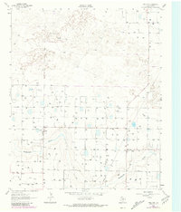
1962 Map of Fieldton
USGS Topo · Published 1965About this map
The agrarian landscape of the Texas Panhandle is captured here through a dense network of water management and small rural hubs. Fieldton and Hart Camp serve as the primary centers of human activity, positioned north of the winding course of Blackwater Draw. The terrain is defined by its agricultural utility, evidenced by the vast number of labels for a Well, indicating the critical importance of groundwater for irrigation in Lamb County during this era.
Find a feature on this map
7 named features on this map. Tap any name to fly to it.
Don’t see what you’re looking for? This feature index may not catch every label — zoom into the map to look around manually.
Map Details
Editions of this 1962 Fieldton Map
2 editions found
Other maps of this area

1954 · Clovis
USGS Topo · 1:250,000

1954 · Brownfield
USGS Topo · 1:250,000

1957 · Anton
USGS Topo · 1:62,500

1958 · Brownfield
USGS Topo · 1:250,000

1958 · Clovis
USGS Topo · 1:250,000

1962 · Brownfield
USGS Topo · 1:250,000

1962 · Cofferville
USGS Topo · 1:24,000

1962 · Springlake
USGS Topo · 1:24,000

1963 · Olton
USGS Topo · 1:24,000

1964 · Littlefield
USGS Topo · 1:24,000