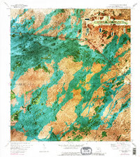
1973 Map of Fiftymile Bend
USGS Topo · Published 1989About this map
The Tamiami Trail (U.S. 41) cuts a sharp diagonal across this orthophotomap of the Florida Everglades, serving as the primary corridor for commerce and travel through the wetlands. Along this route, the small settlement of Fiftymile Bend and the Paolita Station represent the sparse human footprint in a landscape dominated by sawgrass and cypress strands. The map documents a specific moment in Everglades infrastructure, featuring the large Dade-Collier Transition and Training Airport in the northern section and several areas labeled Indian Village, reflecting the cultural presence in the region. Natural features like Corn Dance Hammock and Dayhoff Slough are clearly visible through the aerial imagery, highlighting the complex drainage patterns of the swamp. To the south, the community of Pinecrest stands near a Radio Tower, while the Miami Canal underscores the long history of water management in the territory.
Find a feature on this map
24 named features on this map. Tap any name to fly to it.
Don’t see what you’re looking for? This feature index may not catch every label — zoom into the map to look around manually.
Map Details
Editions of this 1973 Fiftymile Bend Map
3 editions found
Other maps of this area

1956 · Miami
USGS Topo · 1:250,000

1958 · Miami
USGS Topo · 1:250,000

1972 · Shark Valley Lookout Tower
USGS Topo · 1:24,000

1972 · Monroe Station NE
USGS Topo · 1:24,000

1972 · Lostmans Trail
USGS Topo · 1:24,000

1972 · Big Boy Lake
USGS Topo · 1:24,000

1973 · Fortymile Bend
USGS Topo · 1:24,000

1973 · Fiftymile Bend
USGS Topo · 1:24,000

1973 · North Of Fiftymile Bend
USGS Topo · 1:24,000

1973 · Monroe Station
USGS Topo · 1:24,000