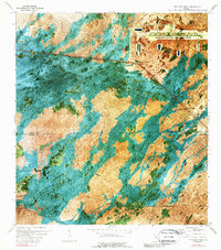
1973 Map of Fiftymile Bend
USGS Topo · Published 1989About this map
Dade-Collier Transition and Training Airport dominates the northeast corner of this remote Big Cypress landscape, its massive runways carved into the wetlands during the early 1970s. The Tamiami Trail and parallel Tamiami Canal slice a straight line across the north, serving as the primary corridor for small outposts like Fiftymile Bend and the Poolita Station. The map illustrates a transition from aviation infrastructure to traditional Everglades navigation, evidenced by the Lostmans Airboat Trail and the Corn Dance Trail winding south. Unique cultural and terrain features are noted throughout the hammocks, including several locations marked as Indian Village, the Trail Gospel Center, and isolated Oil Well sites. The intricate patterns of Roberts Lake Strand and Dayhoff Slough reveal the natural flow of water across the Collier and Monroe County line.
Find a feature on this map
24 named features on this map. Tap any name to fly to it.
Don’t see what you’re looking for? This feature index may not catch every label — zoom into the map to look around manually.
Map Details
Editions of this 1973 Fiftymile Bend Map
3 editions found
Other maps of this area

1956 · Miami
USGS Topo · 1:250,000

1958 · Miami
USGS Topo · 1:250,000

1972 · Shark Valley Lookout Tower
USGS Topo · 1:24,000

1972 · Monroe Station NE
USGS Topo · 1:24,000

1972 · Lostmans Trail
USGS Topo · 1:24,000

1972 · Big Boy Lake
USGS Topo · 1:24,000

1973 · Fortymile Bend
USGS Topo · 1:24,000

1973 · Fiftymile Bend
USGS Topo · 1:24,000

1973 · North Of Fiftymile Bend
USGS Topo · 1:24,000

1973 · Monroe Station
USGS Topo · 1:24,000