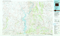
1980 Map of Firehole Canyon
USGS Topo · Published 1993About this map
Flaming Gorge National Recreation Area dominates this 1980 survey, illustrating the managed landscape where the Green River meets high desert plateaus. The map details the reach of the Flaming Gorge Reservoir as it fills the deep cuts of Firehole Canyon and Little Firehole Canyon, creating a complex shoreline at Buckboard Reservoir and Green River Reservoir. This era shows the region's balance between recreation and industry, with a Pumping Sta and a Pipeline network set against the dramatic topography of the Green River Basin.
Find a feature on this map
101 named features on this map. Tap any name to fly to it.
Don’t see what you’re looking for? This feature index may not catch every label — zoom into the map to look around manually.
Map Details
Editions of this 1980 Firehole Canyon Map
2 editions found
Other maps of this area

1885 · Ashley
USGS Topo · 1:250,000

1885 · Uinta
USGS Topo · 1:250,000

1905 · Gilbert Peak
USGS Topo · 1:125,000

1906 · Gilbert Peak
USGS Topo · 1:125,000

1906 · Marsh Peak
USGS Topo · 1:125,000

1908 · Marsh Peak
USGS Topo · 1:125,000

1908 · Rock Springs
USGS Topo · 1:62,500

1910 · Rock Springs
USGS Topo · 1:62,500

1952 · Willow Creek Butte
USGS Topo · 1:24,000

1952 · Clay Basin
USGS Topo · 1:24,000