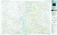
1980 Map of Firehole Canyon
USGS Topo · Published 1993About this map
Flaming Gorge Reservoir dominates this landscape, winding through the complex geology of the Flaming Gorge National Recreation Area during the early 1980s. The map captures the rugged intersection of the Green River and various high-desert features, including the Red Creek Badlands and the towering Quaking Asp Mountain. Significant local landmarks like the Green River Airport and the remote settlement of McKinnon provide anchor points for understanding the regional infrastructure of the day.
Find a feature on this map
66 named features on this map. Tap any name to fly to it.
Don’t see what you’re looking for? This feature index may not catch every label — zoom into the map to look around manually.
Map Details
Editions of this 1980 Firehole Canyon Map
2 editions found
Other maps of this area

1885 · Ashley
USGS Topo · 1:250,000

1885 · Uinta
USGS Topo · 1:250,000

1905 · Gilbert Peak
USGS Topo · 1:125,000

1906 · Gilbert Peak
USGS Topo · 1:125,000

1906 · Marsh Peak
USGS Topo · 1:125,000

1908 · Marsh Peak
USGS Topo · 1:125,000

1908 · Rock Springs
USGS Topo · 1:62,500

1910 · Rock Springs
USGS Topo · 1:62,500

1952 · Willow Creek Butte
USGS Topo · 1:24,000

1952 · Clay Basin
USGS Topo · 1:24,000