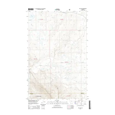
2014 Map of Fish Lake
USGS Topo · Published 2014About this map
The eastern front of the Rockies meets the high plains at the border of Pondera and Teton counties, where the Lewis & Clark National Forest encompasses a landscape defined by significant water management and complex drainages. Central to this topography is the Swift Reservoir, which captures the flow of Birch Cr as it emerges from the higher elevations near Split Mtn. The surrounding area is dotted with numerous small water bodies, including Fish Lake, Cody Lake, and the cluster of Waddel Lakes. Primitive and secondary routes like Heart Butte Rd and Swift Dam Rd provide the primary access through this sparsely settled territory, which also features the smaller Tedson Reservoir to the east. This 2014 survey documents the hydrographic network essential for irrigation and conservation in this part of Montana.
Find a feature on this map
32 named features on this map. Tap any name to fly to it.
Don’t see what you’re looking for? This feature index may not catch every label — zoom into the map to look around manually.
Map Details
Editions of this 2014 Fish Lake Map
This is the sole edition of this map. No revisions or reprints were ever made.
Other maps of this area

1914 · Heart Butte
USGS Topo · 1:125,000

1918 · Heart Butte
USGS Topo · 1:125,000

1960 · Cut Bank
USGS Topo · 1:250,000

1963 · Cut Bank
USGS Topo · 1:250,000

1964 · Cut Bank
USGS Topo · 1:250,000

1968 · Swift Reservoir
USGS Topo · 1:24,000
1968 · Gateway Pass
USGS Topo · 1:24,000

1968 · Fish Lake
USGS Topo · 1:24,000
1968 · Scoffin Butte
USGS Topo · 1:24,000
1968 · Volcano Reef
USGS Topo · 1:24,000