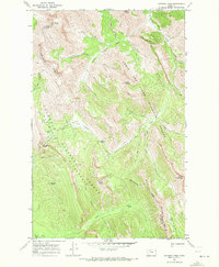
1968 Map of Gateway Pass
USGS Topo · Published 1972About this map
The Continental Divide serves as the high-altitude spine of this landscape, separating the headwaters of the Flathead National Forest to the west from the Lewis and Clark National Forest to the east. This 1968 field survey documents a high-country wilderness area anchored by the Bob Marshall Wilderness. Navigation through the steep drainages depends on established routes like the Gateway Trail and various pack trails that connect the Gateway Cabin to high passes and peaks.
Find a feature on this map
39 named features on this map. Tap any name to fly to it.
Don’t see what you’re looking for? This feature index may not catch every label — zoom into the map to look around manually.
Map Details
Editions of this 1968 Gateway Pass Map
2 editions found
Other maps of this area

1903 · Saypo
USGS Topo · 1:125,000

1913 · Marias Pass
USGS Topo · 1:125,000

1914 · Heart Butte
USGS Topo · 1:125,000

1918 · Heart Butte
USGS Topo · 1:125,000

1936 · Silvertip
USGS Topo · 1:96,000

1942 · Silvertip
USGS Topo · 1:125,000

1955 · Choteau
USGS Topo · 1:250,000

1957 · Choteau
USGS Topo · 1:250,000

1958 · Choteau
USGS Topo · 1:250,000

1958 · Porphyry Reef
USGS Topo · 1:24,000