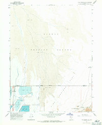
1967 Map of Fish Springs NE
USGS Topo · Published 1971About this map
The Fish Springs National Wildlife Refuge provides a sharp contrast to the surrounding arid terrain, where the managed waters of Gadwall Pool, Ibis Pool, and Egret Pool create a sanctuary at the edge of the Mud Flat. This 1960s survey documents the intersection of conservation and military history, as the refuge borders the Dugway Proving Ground and the Military Reservation.
Find a feature on this map
19 named features on this map. Tap any name to fly to it.
Don’t see what you’re looking for? This feature index may not catch every label — zoom into the map to look around manually.
Map Details
Editions of this 1967 Fish Springs NE Map
4 editions found
Other maps of this area

1908 · Fish Springs
USGS Topo · 1:250,000

1910 · Fish Springs
USGS Topo · 1:250,000

1953 · Dugway Range
USGS Topo · 1:62,500

1953 · Dugway Range NW
USGS Topo · 1:24,000

1953 · Tooele
USGS Topo · 1:250,000

1953 · Delta
USGS Topo · 1:250,000

1954 · Dugway Proving Ground SW
USGS Topo · 1:24,000

1954 · Granite Peak SE
USGS Topo · 1:24,000

1955 · Tooele
USGS Topo · 1:250,000

1958 · Delta
USGS Topo · 1:250,000