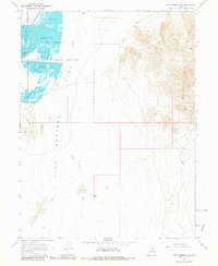
1967 Map of Fish Springs SE
USGS Topo · Published 1981About this map
Fish Springs National Wildlife Refuge dominates the northwestern portion of this 1967 survey, providing a detailed look at the managed wetlands of this high-desert oasis. The map identifies specific avian-named basins including Egret Pool, Curlew Pool, Shoveler Pool, and Avocet Pool. These pools are vital water sources within the larger Fish Springs Flat, a region characterized by expansive mud flats and the drainage of Fish Springs Wash.
Find a feature on this map
15 named features on this map. Tap any name to fly to it.
Don’t see what you’re looking for? This feature index may not catch every label — zoom into the map to look around manually.
Map Details
Editions of this 1967 Fish Springs SE Map
4 editions found

Other maps of this area

1908 · Fish Springs
USGS Topo · 1:250,000

1910 · Fish Springs
USGS Topo · 1:250,000

1953 · Dugway Range
USGS Topo · 1:62,500

1953 · Topaz Mtn
USGS Topo · 1:62,500

1953 · Dugway Range NW
USGS Topo · 1:24,000

1953 · Delta
USGS Topo · 1:250,000

1958 · Delta
USGS Topo · 1:250,000

1962 · Delta
USGS Topo · 1:250,000

1967 · Sand Pass NW
USGS Topo · 1:24,000

1967 · Fish Springs NW
USGS Topo · 1:24,000