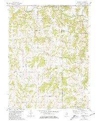
1981 Map of Fishhook
USGS Topo · Published 1981About this map
The community of Fishhook sits on the eastern edge of this 1981 survey, where the rolling landscapes of Beverly and Hadley townships meet the Adams and Pike County line. The terrain is defined by the deep incisions of Mc Kee Creek and its many tributaries, such as Grindstone Creek and Lanes Branch, which create a complex network of ridges including Long Ridge. Historically, this area shows a dense pattern of early rural settlement evidenced by numerous family and community cemeteries, including Fairview Cem, Kurfman Cem, and Rubert Cem. In the northern reaches, Siloam Springs State Park preserves the land around the creek, while to the south, the presence of a Gas Field and a Radio Tower indicates the shifting economic focus toward resource extraction and modern infrastructure in the late twentieth century.
Find a feature on this map
32 named features on this map. Tap any name to fly to it.
Don’t see what you’re looking for? This feature index may not catch every label — zoom into the map to look around manually.
Map Details
Editions of this 1981 Fishhook Map
This is the sole edition of this map. No revisions or reprints were ever made.
Other maps of this area

1925 · Liberty
USGS Topo · 1:62,500

1926 · Pittsfield
USGS Topo · 1:62,500

1926 · Mt Sterling
USGS Topo · 1:62,500

1927 · Liberty
USGS Topo · 1:62,500

1929 · Mt Sterling
USGS Topo · 1:62,500

1931 · Barry
USGS Topo · 1:62,500

1936 · Barry
USGS Topo · 1:48,000

1944 · Barry
USGS Topo · 1:62,500

1948 · Quincy
USGS Topo · 1:250,000

1956 · Quincy
USGS Topo · 1:250,000