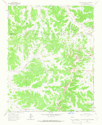
1963 Map of Five Lakes Canyon NE
USGS Topo · Published 1966About this map
The Continental Divide winds through this high-altitude landscape on the border of Sandoval and Rio Arriba counties, defining a rugged terrain of deep canyons and natural basins. The mid-1960s survey documents a region characterized by its drainage patterns and subterranean resources, marked by scattered Gas Wells and Drill Holes that signal the era's energy exploration. In the south, the San Jose Lakes and the headwaters of Five Lakes Canyon provide a stark contrast to the nearby Badland Hills. Water movement is traced through intricate systems like Arroyo Valles and Menfee Canyon, which feed into larger watercourses such as Larga Creek and Canada Larga. This map records the intersection of geological boundaries and industrial utility in a remote New Mexico wilderness.
Find a feature on this map
14 named features on this map. Tap any name to fly to it.
Don’t see what you’re looking for? This feature index may not catch every label — zoom into the map to look around manually.
Map Details
Editions of this 1963 Five Lakes Canyon NE Map
2 editions found
Other maps of this area

1889 · Largo
USGS Topo · 1:250,000

1895 · Largo
USGS Topo · 1:250,000

1909 · Gallina
USGS Topo · 1:125,000

1940 · Cuba
USGS Topo · 1:62,500

1943 · Cuba
USGS Topo · 1:62,500

1954 · Aztec
USGS Topo · 1:250,000

1955 · Llaves
USGS Topo · 1:62,500

1958 · Aztec
USGS Topo · 1:250,000

1962 · Aztec
USGS Topo · 1:250,000

1963 · Lindrith
USGS Topo · 1:24,000