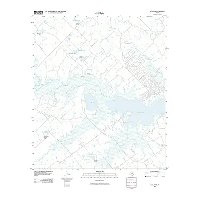
2010 Map of Flag Pond
USGS Topo · Published 2010About this map
Somerville Lake dominates the central landscape of this East Texas region, where the winding course of Yegua Creek meets the expansive waters of Flag Pond. The map reveals a land defined by water management and rural settlement, characterized by numerous private reservoirs such as Schindler Lake, Gerland Lake, and Bredthauer Lake, each with its own established dam. This hydrologic pattern suggests a reliance on local water sources for agriculture or livestock in the early 21st century. Cultural markers like Birch Cemetery and Flat Prairie Cemetery provide fixed points of reference for genealogists, while the road network, including FM 180 RD and FM 60, connects scattered homesteads. The intricate network of smaller creeks like Nails Creek, Cedar Creek, and McCoin Creek underscores the complex drainage system feeding into the larger reservoir basin.
Find a feature on this map
56 named features on this map. Tap any name to fly to it.
Don’t see what you’re looking for? This feature index may not catch every label — zoom into the map to look around manually.
Map Details
Editions of this 2010 Flag Pond Map
This is the sole edition of this map. No revisions or reprints were ever made.
Other maps of this area

1919 · Giddings
USGS Topo · 1:62,500

1919 · Dime Box
USGS Topo · 1:62,500

1954 · Austin
USGS Topo · 1:250,000

1956 · Somerville
USGS Topo · 1:62,500

1958 · Ledbetter
USGS Topo · 1:24,000

1958 · Carmine
USGS Topo · 1:24,000

1958 · Burton
USGS Topo · 1:24,000

1959 · Flag Pond
USGS Topo · 1:24,000

1959 · Somerville
USGS Topo · 1:24,000
1959 · Dime Box
USGS Topo · 1:24,000