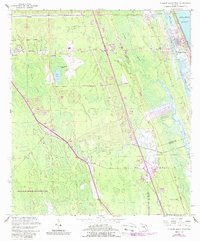
1956 Map of Flagler Beach West
USGS Topo · Published 1988About this map
Bunnell serves as a primary hub in this coastal Florida landscape, where the flatlands of the interior meet the intricate hydrology of the Atlantic seaboard. The settlement pattern follows the established transportation corridors, with small communities like Dupont and Korona situated along the rail and road lines that parallel the coast. To the east, the Intracoastal Waterway and Smith Creek separate the barrier island of Flagler Beach from the mainland swamps.
Find a feature on this map
24 named features on this map. Tap any name to fly to it.
Don’t see what you’re looking for? This feature index may not catch every label — zoom into the map to look around manually.
Map Details
Editions of this 1956 Flagler Beach West Map
5 editions found

Other maps of this area

1927 · Matanzas
USGS Topo · 1:48,000

1937 · Dinner Island
USGS Topo · 1:48,000

1937 · Ormond
USGS Topo · 1:48,000

1943 · Dinner Island
USGS Topo · 1:62,500

1943 · Matanzas
USGS Topo · 1:62,500

1944 · Ormond
USGS Topo · 1:62,500

1944 · Dinner Island
USGS Topo · 1:62,500

1944 · Matanzas
USGS Topo · 1:62,500

1954 · Daytona Beach
USGS Topo · 1:250,000

1956 · Favoretta
USGS Topo · 1:24,000