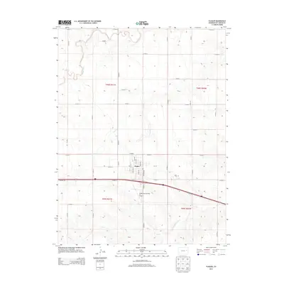
2013 Map of Flagler
USGS Topo · Published 2013About this map
Flagler serves as the central hub of this eastern Colorado landscape, where the High Plains terrain is etched by the meandering courses of Buffalo Creek, Duck Cr, and Mud Cr. The town's grid is clearly defined by named thoroughfares such as Main Ave and E High St, reflecting its role as a regional anchor in Kit Carson County. Agricultural aviation is a prominent feature of the local economy, anchored by the Flagler Aerial Spraying Inc Airport situated just southeast of the town center. To the south, the S Fork Republican River cuts through the township boundaries of t009s r051w and t009s r050w, while the Flagler Cem stands on the eastern outskirts near CO Road 6. The map captures a moment in the early 21st century when the traditional section-line road network remained the primary framework for this prairie community.
Find a feature on this map
39 named features on this map. Tap any name to fly to it.
Don’t see what you’re looking for? This feature index may not catch every label — zoom into the map to look around manually.
Map Details
Editions of this 2013 Flagler Map
This is the sole edition of this map. No revisions or reprints were ever made.
Other maps of this area

1954 · Limon
USGS Topo · 1:250,000

1957 · Limon
USGS Topo · 1:250,000

1958 · Limon
USGS Topo · 1:250,000

1978 · Hugo 4 NW
USGS Topo · 1:24,000

1979 · Hugo 4 NE
USGS Topo · 1:24,000

1979 · Flagler SW
USGS Topo · 1:24,000

1979 · Flagler NW
USGS Topo · 1:24,000

1979 · Flagler
USGS Topo · 1:24,000
1979 · Hugo 4 NW
USGS Topo · 1:24,000
1979 · Flagler NE
USGS Topo · 1:24,000