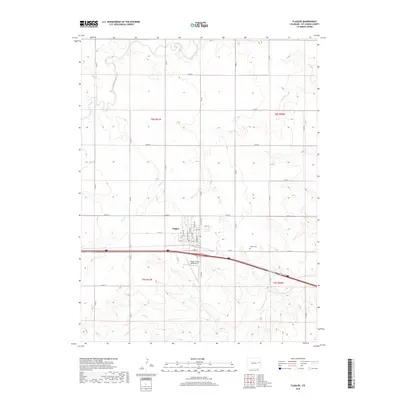
2019 Map of Flagler
USGS Topo · Published 2019About this map
Flagler serves as the central hub of this High Plains landscape, situated near the headwaters of the S Fork Republican River. The town's grid is clearly defined by named thoroughfares such as Main Ave, Navajo Ave, and Loveland Ave, reflecting its established residential and commercial footprint. To the east, the Flagler Cem stands on a gentle rise, while the local economy's agricultural ties are evidenced by Flagler Aerial Spraying Inc located south of the main settlement.
Find a feature on this map
43 named features on this map. Tap any name to fly to it.
Don’t see what you’re looking for? This feature index may not catch every label — zoom into the map to look around manually.
Map Details
Editions of this 2019 Flagler Map
This is the sole edition of this map. No revisions or reprints were ever made.
Other maps of this area

1954 · Limon
USGS Topo · 1:250,000

1957 · Limon
USGS Topo · 1:250,000

1958 · Limon
USGS Topo · 1:250,000

1978 · Hugo 4 NW
USGS Topo · 1:24,000

1979 · Hugo 4 NE
USGS Topo · 1:24,000

1979 · Flagler SW
USGS Topo · 1:24,000

1979 · Flagler NW
USGS Topo · 1:24,000

1979 · Flagler
USGS Topo · 1:24,000
1979 · Hugo 4 NW
USGS Topo · 1:24,000
1979 · Flagler NE
USGS Topo · 1:24,000