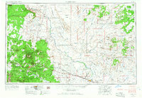
1954 Map of Flagstaff
USGS Topo · Published 1966About this map
The high desert and volcanic peaks of northern Arizona are captured in this mid-century survey, revealing a landscape defined by expansive tribal lands and early transcontinental travel routes. At the foot of San Francisco Mountain, the community of Flagstaff serves as a hub for the Atchison Topeka and Santa Fe railroad, which parallels U.S. Route 66. To the west, the Navajo Ordnance Depot indicates the region's military significance during and after the war. Moving east, the terrain transitions into the Painted Desert and the high mesas of the Hopi Indian Reservation, where ancient settlements like Oraibi and Shongopovi are documented alongside Bureau of Indian Affairs sites like Keams Canyon. This edition captures the era of the roadside trading post, featuring local landmarks such as the Buck Rodgers Trading Post and the appropriately named Meteor City near the famous impact crater.
Find a feature on this map
175 named features on this map. Tap any name to fly to it.
Don’t see what you’re looking for? This feature index may not catch every label — zoom into the map to look around manually.
Map Details
Editions of this 1954 Flagstaff Map
3 editions found

Other maps of this area

1883 · Marsh Pass
USGS Topo · 1:250,000

1883 · Tusayan
USGS Topo · 1:250,000

1886 · St Johns
USGS Topo · 1:250,000

1886 · Tusayan
USGS Topo · 1:250,000

1886 · Fort Defiance
USGS Topo · 1:250,000

1886 · San Francisco Mtns
USGS Topo · 1:250,000

1886 · Chino
USGS Topo · 1:250,000

1886 · Echo Cliffs
USGS Topo · 1:250,000

1886 · Holbrook
USGS Topo · 1:250,000

1886 · Kaibab
USGS Topo · 1:250,000