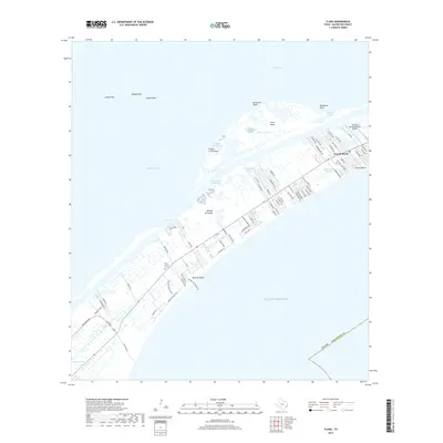
2019 Map of Flake
USGS Topo · Published 2019About this map
Bolivar Peninsula stretches between the Gulf of Mexico and Galveston Bay, showcasing a landscape defined by coastal salt marshes, tidal inlets, and residential expansion. In the eastern portion, Crystal Beach exhibits a dense grid of beach-access roads and canals, while the western reaches remain more topographical with features like Dredgeboat Slough and Sievers Cove. The Intracoastal Waterway serves as a vital artery for maritime traffic, separating the main peninsula from islands such as Goat Island. Genealogists and local researchers can locate the Port Bolivar Cem near the center of the peninsula, providing a fixed point of historical reference amidst the shifting sands of Bolivar Beach. From the aviation facilities at Seafood Warehouse Park Airport to the reefs of Hanna Reef, this survey documents the complex geography of the Texas coast.
Find a feature on this map
84 named features on this map. Tap any name to fly to it.
Don’t see what you’re looking for? This feature index may not catch every label — zoom into the map to look around manually.
Map Details
Editions of this 2019 Flake Map
This is the sole edition of this map. No revisions or reprints were ever made.
Other maps of this area

1930 · Galveston
USGS Topo · 1:24,000

1931 · Flake
USGS Topo · 1:24,000

1931 · Frozen Point
USGS Topo · 1:24,000

1932 · Bolivar Point
USGS Topo · 1:24,000

1933 · Frozen Point
USGS Topo · 1:31,680

1933 · Caplen
USGS Topo · 1:31,680

1933 · The Jetties
USGS Topo · 1:31,680

1933 · Whites Lake
USGS Topo · 1:31,680

1933 · Smith Point
USGS Topo · 1:31,680

1933 · Bolivar Point
USGS Topo · 1:31,680