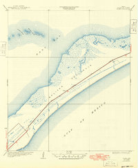
1933 Map of Flake
USGS Topo · Published 1949About this map
Bolivar Peninsula stretches between the saltwater of East Bay and the open Gulf of Mexico in this early 1930s survey. The narrow coastal strip is defined by the strategic route of the Gulf Colorado and Santa Fe, which runs the length of the landmass, linking the isolated settlement of Flake to the mainland. The coastal geography is highly detailed, showing the intricate network of marshlands and tidal inlets along the bay side, including Ladies Pass and Moodys Pass. Just offshore, Hannah Reef breaks the waters of the bay, marking a landscape where the economy and transport were tied directly to the sea and the rail line. This document, compiled in part from Air Corps aerial photographs, records the precise shoreline and cultural features of Galveston County before significant mid-century development altered the peninsula's character.
Find a feature on this map
9 named features on this map. Tap any name to fly to it.
Don’t see what you’re looking for? This feature index may not catch every label — zoom into the map to look around manually.
Map Details
Editions of this 1933 Flake Map
2 editions found

Other maps of this area

1930 · Galveston
USGS Topo · 1:24,000

1931 · Flake
USGS Topo · 1:24,000

1931 · Frozen Point
USGS Topo · 1:24,000

1932 · Bolivar Point
USGS Topo · 1:24,000

1933 · Frozen Point
USGS Topo · 1:31,680

1933 · Caplen
USGS Topo · 1:31,680

1933 · The Jetties
USGS Topo · 1:31,680

1933 · Whites Lake
USGS Topo · 1:31,680

1933 · Smith Point
USGS Topo · 1:31,680

1933 · Bolivar Point
USGS Topo · 1:31,680