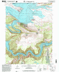
1996 Map of Flaming George
USGS Topo · Published 1999About this map
The Flaming Gorge Reservoir dominates this high-desert landscape where the Green River carves through the northern reaches of the Ashley National Forest. This 1996 revision shows a transition from the broad, open waters of Lucerne Valley and Linwood Bay to the narrow, high-walled confines of Red Canyon and Horseshoe Canyon. The map details the recreational infrastructure established after the damming of the river, including the Lucerne Valley Marina, the Red Canyon Visitor Center, and several developed boat ramps.
Find a feature on this map
37 named features on this map. Tap any name to fly to it.
Don’t see what you’re looking for? This feature index may not catch every label — zoom into the map to look around manually.
Map Details
Editions of this 1996 Flaming George Map
This is the sole edition of this map. No revisions or reprints were ever made.
Other maps of this area

1885 · Ashley
USGS Topo · 1:250,000

1906 · Marsh Peak
USGS Topo · 1:125,000

1908 · Marsh Peak
USGS Topo · 1:125,000

1952 · Dutch John Mtn
USGS Topo · 1:24,000

1952 · Flaming Gorge
USGS Topo · 1:24,000

1954 · Vernal
USGS Topo · 1:250,000

1954 · Rock Springs
USGS Topo · 1:250,000

1957 · Currant Creek Ranch
USGS Topo · 1:62,500

1958 · Vernal
USGS Topo · 1:250,000

1958 · Rock Springs
USGS Topo · 1:250,000