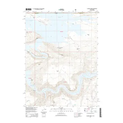
2014 Map of Flaming Gorge
USGS Topo · Published 2014About this map
Ashley National Forest dominates this 2014 survey of the Utah-Wyoming borderlands, where the high desert terrain meets the expansive waters of the Flaming Gorge Reservoir. The landscape is defined by its deep, winding canyons and prominent topographical markers like the volcanic landmark Boars Tusk and the steep elevation of Bare Top Mtn. The small settlement of Greendale sits near the southern edge of the sheet, providing a human anchor in a territory largely characterized by dramatic drainage systems like N Skull Cr and Red Canyon. This map documents the complex management of the reservoir's recreation areas, showing the interplay between forest roads such as Forest Rd 94 and the water-filled recesses of Hideout Canyon and Horseshoe Canyon. It captures a modern state of the reservoir's shoreline and the diverse plateaus, including Antelope Flat, that surround this high-altitude water body.
Find a feature on this map
26 named features on this map. Tap any name to fly to it.
Don’t see what you’re looking for? This feature index may not catch every label — zoom into the map to look around manually.
Map Details
Editions of this 2014 Flaming Gorge Map
This is the sole edition of this map. No revisions or reprints were ever made.
Other maps of this area

1885 · Ashley
USGS Topo · 1:250,000

1906 · Marsh Peak
USGS Topo · 1:125,000

1908 · Marsh Peak
USGS Topo · 1:125,000

1952 · Dutch John Mtn
USGS Topo · 1:24,000

1952 · Flaming Gorge
USGS Topo · 1:24,000

1954 · Vernal
USGS Topo · 1:250,000

1954 · Rock Springs
USGS Topo · 1:250,000

1957 · Currant Creek Ranch
USGS Topo · 1:62,500

1958 · Vernal
USGS Topo · 1:250,000

1958 · Rock Springs
USGS Topo · 1:250,000