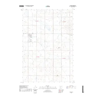
2018 Map of Flasher
USGS Topo · Published 2018About this map
Flasher serves as the focal point of this Morton County survey, situated at the intersection of several section-line roads and the winding path of Louse Cr. The settlement is characterized by its organized street grid, including N Main St and College St, and its surrounding burial grounds such as Hillside Cem and Saint Lawrence Catholic Cem. This modern dataset illustrates a landscape where agricultural section lines dictate the movement of people across the high plains, punctuated by prominent landforms like Long Butte and Rattlesnake Hill. North of the town center, Lake Patricia and its namesake Lake Patricia Rd provide a distinct contrast to the drainages of Chanta Peta Cr and E Fork Chanta Peta Cr that carve through the northern and eastern reaches of the quadrangle.
Find a feature on this map
37 named features on this map. Tap any name to fly to it.
Don’t see what you’re looking for? This feature index may not catch every label — zoom into the map to look around manually.
Map Details
Editions of this 2018 Flasher Map
This is the sole edition of this map. No revisions or reprints were ever made.
Other maps of this area

1954 · Bismarck
USGS Topo · 1:250,000

1958 · Bismarck
USGS Topo · 1:250,000

1971 · Timmer
USGS Topo · 1:24,000

1980 · Otter Creek East
USGS Topo · 1:24,000

1980 · Freda
USGS Topo · 1:24,000

1980 · Burgess
USGS Topo · 1:24,000

1980 · Dogtooth Buttes
USGS Topo · 1:24,000

1980 · Raleigh
USGS Topo · 1:24,000

1980 · Nygren Dam
USGS Topo · 1:24,000
1980 · Elgin
USGS Topo · 1:100,000