
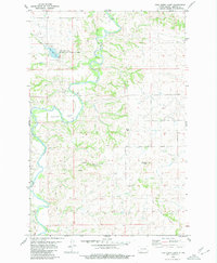
1980 Map of Otter Creek East
USGS Topo · Published 1980About this map
The Heart River winds through the northern portion of this landscape on the border of Grant and Morton Counties, creating a complex network of drainages and coulees. This 1980 survey emphasizes the transition from the river valley to the upland plains, where conservation and land management are anchored by the Otter Creek State Game Management Area. The terrain is defined by its watercourses, including Otter Creek, Beaver Creek, and Cow Creek, which carve through the prairie. Smaller features like Bridge Coulee and Pony Coulee illustrate the local topography, while scattered wells indicate the ongoing human interaction with the land for resource extraction and agriculture during the late twentieth century.
Find a feature on this map
10 named features on this map. Tap any name to fly to it.
Don’t see what you’re looking for? This feature index may not catch every label — zoom into the map to look around manually.
Map Details
Editions of this 1980 Otter Creek East Map
This is the sole edition of this map. No revisions or reprints were ever made.
Other maps of this area

1954 · Bismarck
USGS Topo · 1:250,000

1958 · Bismarck
USGS Topo · 1:250,000

1980 · Otter Creek West
USGS Topo · 1:24,000

1980 · Green Ridge
USGS Topo · 1:24,000

1980 · Almont East
USGS Topo · 1:24,000

1980 · Lark
USGS Topo · 1:24,000

1980 · Dogtooth Buttes
USGS Topo · 1:24,000
1980 · Fish Creek Lake
USGS Topo · 1:24,000

1980 · Nygren Dam
USGS Topo · 1:24,000
1980 · Elgin
USGS Topo · 1:100,000