
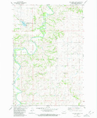
1980 Map of Green Ridge
USGS Topo · Published 1980About this map
Green Ridge rises as a prominent topographical feature in this rural landscape of Morton County, spanning the line with Grant County to the south. The area is defined by its agricultural and pastoral character, evidenced by scattered Well sites and Storage Bins used for grain storage. Beaver Creek and Fish Creek provide the primary drainage for this prairie terrain, where natural water sources like Spring were critical for early ranching and farming operations.
Find a feature on this map
11 named features on this map. Tap any name to fly to it.
Don’t see what you’re looking for? This feature index may not catch every label — zoom into the map to look around manually.
Map Details
Editions of this 1980 Green Ridge Map
This is the sole edition of this map. No revisions or reprints were ever made.
Other maps of this area

1954 · Bismarck
USGS Topo · 1:250,000

1958 · Bismarck
USGS Topo · 1:250,000

1960 · New Salem
USGS Topo · 1:24,000

1970 · Judson
USGS Topo · 1:24,000

1972 · Sweet Briar
USGS Topo · 1:24,000

1980 · Otter Creek West
USGS Topo · 1:24,000

1980 · Otter Creek East
USGS Topo · 1:24,000

1980 · Almont East
USGS Topo · 1:24,000
1980 · Fish Creek Lake
USGS Topo · 1:24,000

1980 · Nygren Dam
USGS Topo · 1:24,000