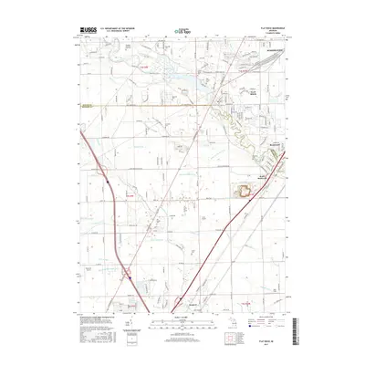
2017 Map of Flat Rock
USGS Topo · Published 2017About this map
The Huron River serves as the primary corridor for this region, anchoring the growth of Flat Rock and Rockwood. This landscape is defined by an intricate network of agricultural and municipal drainage systems, such as the Wagner and Pink Drain, Vandecar Drain, and Laudenschlager Drain, which manage the low-lying terrain as it transitions toward Lake Erie. The map reveals a dense concentration of memorial sites and family burial grounds, including the large Michigan Memorial Park Cem and the smaller Potter Cem. Further south, the map illustrates the more open rural character of Newport and the presence of small local aviation landmarks like Carls Airport and Buzzwick Airport, alongside the industrial and residential expansion of Woodhaven in the northeast.
Find a feature on this map
188 named features on this map. Tap any name to fly to it.
Don’t see what you’re looking for? This feature index may not catch every label — zoom into the map to look around manually.
Map Details
Editions of this 2017 Flat Rock Map
This is the sole edition of this map. No revisions or reprints were ever made.
Other maps of this area

1906 · Wyandotte
USGS Topo · 1:62,500

1906 · Romulus
USGS Topo · 1:62,500

1912 · Wyandotte
USGS Topo · 1:62,500

1912 · Monroe
USGS Topo · 1:62,500

1914 · Monroe
USGS Topo · 1:62,500

1927 · Monroe
USGS Topo · 1:31,680

1928 · Romulus
USGS Topo · 1:62,500

1929 · Wyandotte
USGS Topo · 1:62,500

1936 · Wyandotte
USGS Topo · 1:31,680
1936 · Belleville
USGS Topo · 1:31,680
Featured Places
- Brownstown Charter Township, MI
- Frenchtown Charter Township, MI
- Huron Charter Township, MI
- Woodhaven, MI
- Berlin Charter Township, MI