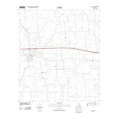
2010 Map of Flatonia
USGS Topo · Published 2010About this map
Flatonia serves as the central hub of this South Texas landscape, where the Union Pacific railroad corridor dictates the local geography. The map reveals a distinct historical shift from Old Flatonia to the current town site, reflecting the influence of 19th-century rail development on Fayette County settlements. To the southeast, the small community of Praha remains a significant point of interest, anchored by the Slavonic Cemetery and a network of rural roads such as FM 1295. The terrain is defined by a series of drainage systems, including Mulberry Creek and Big Rocky Creek, which carve through the countryside near Obar Hill. Numerous family-named roads and localized cemeteries, like the Criswell Cemetery and Pine Springs Cemetery, provide essential spatial data for genealogists tracing ancestral landholdings in this agricultural region.
Find a feature on this map
68 named features on this map. Tap any name to fly to it.
Don’t see what you’re looking for? This feature index may not catch every label — zoom into the map to look around manually.
Map Details
Editions of this 2010 Flatonia Map
This is the sole edition of this map. No revisions or reprints were ever made.
Other maps of this area

1901 · Flatonia
USGS Topo · 1:125,000

1919 · Schulenburg
USGS Topo · 1:62,500

1953 · Seguin
USGS Topo · 1:250,000

1956 · La Grange
USGS Topo · 1:62,500

1958 · Seguin
USGS Topo · 1:250,000

1965 · Muldoon
USGS Topo · 1:24,000

1965 · Schulenburg
USGS Topo · 1:24,000

1965 · Cistern
USGS Topo · 1:24,000
1965 · Swiss Alp
USGS Topo · 1:24,000

1965 · Komensky
USGS Topo · 1:24,000