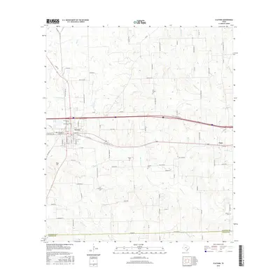
2016 Map of Flatonia
USGS Topo · Published 2016About this map
The railroad town of Flatonia serves as the focal point of this Fayette County survey, where the intersecting lines of transit and agriculture define the landscape. This 2016 edition provides a clear record of the area's rural character, stretching from the small settlement of Engle in the east toward the rolling terrain of Obar Hill in the west. The map is particularly dense with genealogical sites, documenting numerous burial grounds such as Old Flatonia Cem, Sacred Heart Cem, and Slavonic Cem. Waterways like Mulberry Cr, Big Rocky Cr, and Coldwater Cr carve through the cattle-dotted plains, illustrating the drainage patterns essential to the local ranching economy. The detailed road network includes historic thoroughfares like the Old Smithville Rd and the Old Spanish Trl, reflecting the deep layers of transportation history in this part of Texas.
Find a feature on this map
101 named features on this map. Tap any name to fly to it.
Don’t see what you’re looking for? This feature index may not catch every label — zoom into the map to look around manually.
Map Details
Editions of this 2016 Flatonia Map
This is the sole edition of this map. No revisions or reprints were ever made.
Other maps of this area

1901 · Flatonia
USGS Topo · 1:125,000

1919 · Schulenburg
USGS Topo · 1:62,500

1953 · Seguin
USGS Topo · 1:250,000

1956 · La Grange
USGS Topo · 1:62,500

1958 · Seguin
USGS Topo · 1:250,000

1965 · Muldoon
USGS Topo · 1:24,000

1965 · Schulenburg
USGS Topo · 1:24,000

1965 · Cistern
USGS Topo · 1:24,000
1965 · Swiss Alp
USGS Topo · 1:24,000

1965 · Komensky
USGS Topo · 1:24,000